Real world maps vs Fantasy Maps: Which makes sense?
Over the past few years I’ve been introduced to a number of ways that gamers are using apps to turn real world maps into gaming platforms.
The first example I ever encountered was a game called “Ghost Escape”. Essentially the game took a smart phone’s GPS and implanted “ghost sightings” on it. Players would use the map to locate the ghosts, scoring points.
It was simple, straight forward, and turned the real world into a game board.
A recent venture into this would be kids game “Dragons Adventure”. This tablet game allows children on road trips to fly DreamWorks characters and dragons through the same terrain they are driving past, weather and all.
Of course, these interactions are all designed and built using the latest GIS technologies and GPS systems and modeling software and programmed by serious code monkeys. Fortunately, us old school gamers can utilize some of the same principles without having to be app designers equipped with phones that are smarter than we are or $500 software.
We just need to know what makes real world maps so fascinating people design games around them, then design our maps to capture the same things.
When you pull out a real world map there are certain things about it that just make sense. Let’s take a look at an example.
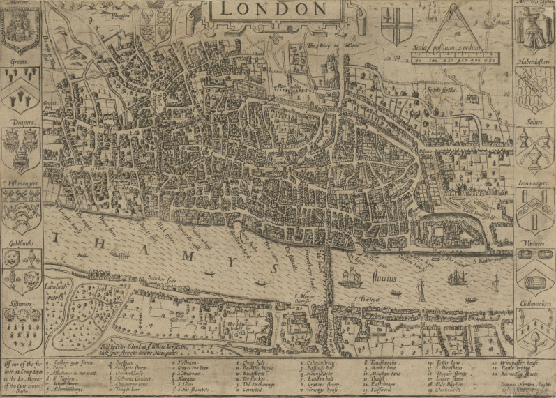
This is London in 1653.
As you look at it you discover that there are a lot of elements about the city that just plain make sense when you think about them.
First, there’s the distribution of the city in regards to the map. Notice that there is next to nothing of the city on the south bank.
At first that might seem odd, but think about it.
The Thames is a huge river, and London formed as a trade town specifically because it was a good location for ocean traffic to find a safe harbor. Bridging the Thames blocks off access to the river for ship traffic, so it is not something you would do unless overland traffic had become far more valuable.
Once trade was established on the North bank, anyone who tried to build on the South bank would be cut off from the actual trade center and all of its amenities by the river. So the city grew exclusively on the northern side. Only with the bridging of the river on a permanent basis would the south start seeing significant development.
This same logic explains the position of the castle on the map.
That’s the Tower of London. If you visited it today it’d be near the heart of the city. But on this early map, it’s very much on the edge of both the town and the river.
Again, taking in mind the purpose of London, it makes sense.
The same sea trade that made London the thriving trade hub it was also represented the biggest approach of attack on the city.
A raiding fleet could sale right up to the city armed to the scuppers with soldiers and siege weapons.
By putting the fortress right at the start of town and directly on the bank you have your strongest city defenses poised to destroy anything trying to get at the soft and flammable buildings upstream. The other defenses are scattered throughout the city, at times on an edge, and other times buried deep in the guts of the town. The city didn’t stop growing because someone built a wall. It kept expanding, spilling out over the walls and rendering them moot.
Then, finally, there’s the roads.
When you look at that map of London there’s not a straight road on there.
Again, though, this makes sense.
London was not some sort of planned city using protractors and rulers to lay it out. When people started settling there they built along the river and expanded outward by following cattle trails and goat paths. As the animals wandered from watering spots to grazing spots their trails twisted in and about the terrain. So, to, did the roads that people formed by using those trails, and so follows the paths of the buildings lining those roads.
It’s an organic structure, messy, convoluted, and very natural.
Now, to contrast that, let’s take a look at a map of one of the most famous fantasy settings out there.
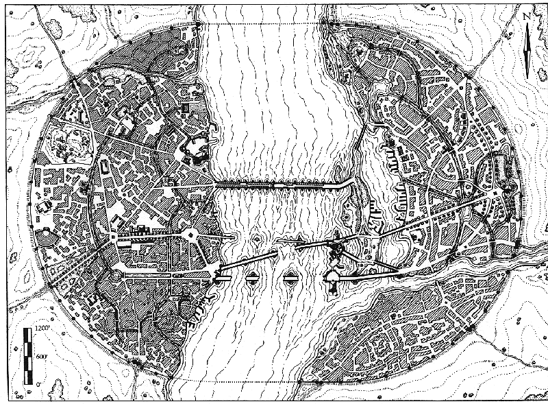
This is a map of Tolkein’s Osgiliath (post-abandonment).
The one-time capital of Gondor in The Lord of the Rings.

Like London it’s a city built on a major river and serves as a port for ships full of cargo.
But look at how everything is arranged.
I’m a major fan of Tolkien, but this city makes no sense when you start thinking of it practically. First, the city is almost evenly distributed across both banks of the river.
Think about that.
This river is nearly half a mile wide, but the population managed to nicely build their city evenly on both banks. The only way this would make sense would be if they bridged the river right off the bat. They would only do that if they felt the loss of all river traffic north of the bridge was worth it, and frankly, it wouldn’t be for a long time to come.
Worse, the Southeastern quarter is cut off from the Northeastern quarter by the tributary flowing from Minas Ithil. There’s no bridge, no way to get across it. And yet it is as heavily built up as the rest of the city.
As for the bridges…
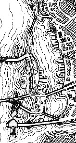
 These two sides are joined by bridges that are even more nonsensical than the sides themselves. As you can see, near the shore of the East bank are a series of islands that form a natural port separated from the rest of the river. However, both ends of that port are blocked off by bridges. There are numerous docks and wharfs and no way to access them with vessels larger than overgrown canoes.
Then there are the defenses.
Osgiliath’s primary bastion may be on the banks of the river as well, but it’s also as close to the center of the city as you can get without actually getting in the water. That’s it edging slightly into the Northwest portion of the map.
There’s not a single portion of the city that it actually defends.
In fact, the bridges are protecting it from any water bound attacks coming from the sea. This makes no tactical sense.
Added to that, the outer walls don’t feels natural or real. Their perfectly circular arcs don’t conform to the landscape. Rather, they force the landscape to conform to them.
This is city planning at its most draconic, allowing no room for development.
When you look at the contour lines it is clear that the landscape has either been dug out and evened to fit the city, or that the landscape was unnatural indeed. Further, the city has been forced to conform to the walls. There is no waste space inside the walls, nor are there any structures outside.
Then there are the roads. While there are certainly roads which twist and turn like those of London, all of the major roads have been placed with a straight edge.
Unlike London, whose most important streets are the goat paths that were built along first, someone has bulldozed a straight path through whatever development had existed before to create order. As for those that do twist and wiggle many look less like they are wandering someplace and more like they are being impeded and blocked at every turn by the buildings.
Osgiliath, according to this map, just doesn’t feel natural.
It doesn’t look like something that was founded in a place that made sense and then grew from there, it feels like something that was created whole cloth in defiance of the very reason it was located where it is. It simply does not make sense.
So what’s the takeaway here?
The real world map of London makes a better fantasy setting than the fantasy map of Osgiliath.
Looking at a map of London you get this sense of a living, growing city that has a history and a reason to exist. It excites you about the possibilities of being someplace vibrant and a touch unruly.
By comparison Osgiliath feels sterile, like it always has been there and always will be, and never will it be touched by anything so puerile as history.
When you are working to create maps for your fantasy setting take lessons from real world geography.
Real World Maps Make Sense
Build your fantasy cities like the cities actually live. Found them in a location that makes sense, and then have the cities grow up over time around that city. Grab something like Campaign Cartographer, AutoREALM or a blank map; plug in a geography that makes sense for the campaign, and then grow the city over time.
I guarantee that building fantasy maps the way real world maps formed will result in a more natural and exciting setting.
About the Author
James Hinton is an old school gamer who first fell in love with maps thanks to National Geographic. He now lives in Idaho where he spends his time attempting to force his daughters to give up their laptops for AD&D 1st Ed.
