Real world maps vs Fantasy Maps: Which makes sense?

·

Real world maps vs Fantasy Maps: Which makes sense?

Over the past few years I’ve been introduced to a number of ways that gamers are using apps to turn real world maps into gaming platforms.

The first example I ever encountered was a game called “Ghost Escape”. Essentially the game took a smart phone’s GPS and implanted “ghost sightings” on it. Players would use the map to locate the ghosts, scoring points.

It was simple, straight forward, and turned the real world into a game board.

A recent venture into this would be kids game “Dragons Adventure”. This tablet game allows children on road trips to fly DreamWorks characters and dragons through the same terrain they are driving past, weather and all.

Of course, these interactions are all designed and built using the latest GIS technologies and GPS systems and modeling software and programmed by serious code monkeys. Fortunately, us old school gamers can utilize some of the same principles without having to be app designers equipped with phones that are smarter than we are or $500 software.

We just need to know what makes real world maps so fascinating people design games around them, then design our maps to capture the same things.

When you pull out a real world map there are certain things about it that just make sense. Let’s take a look at an example.

This is London in 1653.
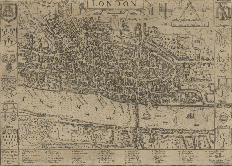
Map of London in 1593

As you look at it you discover that there are a lot of elements about the city that just plain make sense when you think about them.

First, there’s the distribution of the city in regards to the map. Notice that there is next to nothing of the city on the south bank.

At first that might seem odd, but think about it.

The Thames is a huge river, and London formed as a trade town specifically because it was a good location for ocean traffic to find a safe harbor. Bridging the Thames blocks off access to the river for ship traffic, so it is not something you would do unless overland traffic had become far more valuable.

Once trade was established on the North bank, anyone who tried to build on the South bank would be cut off from the actual trade center and all of its amenities by the river. So the city grew exclusively on the northern side. Only with the bridging of the river on a permanent basis would the south start seeing significant development.

This same logic explains the position of the castle on the map.

That’s the Tower of London. If you visited it today it’d be near the heart of the city. But on this early map, it’s very much on the edge of both the town and the river.

Again, taking in mind the purpose of London, it makes sense.

The same sea trade that made London the thriving trade hub it was also represented the biggest approach of attack on the city.

A raiding fleet could sale right up to the city armed to the scuppers with soldiers and siege weapons.

By putting the fortress right at the start of town and directly on the bank you have your strongest city defenses poised to destroy anything trying to get at the soft and flammable buildings upstream. The other defenses are scattered throughout the city, at times on an edge, and other times buried deep in the guts of the town. The city didn’t stop growing because someone built a wall. It kept expanding, spilling out over the walls and rendering them moot.

Then, finally, there’s the roads.

When you look at that map of London there’s not a straight road on there.

Again, though, this makes sense.

London was not some sort of planned city using protractors and rulers to lay it out. When people started settling there they built along the river and expanded outward by following cattle trails and goat paths. As the animals wandered from watering spots to grazing spots their trails twisted in and about the terrain. So, to, did the roads that people formed by using those trails, and so follows the paths of the buildings lining those roads.

It’s an organic structure, messy, convoluted, and very natural.

Now, to contrast that, let’s take a look at a map of one of the most famous fantasy settings out there.

This is a map of Tolkein’s Osgiliath (post-abandonment).

The one-time capital of Gondor in The Lord of the Rings.
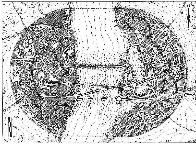
A map of Tolkein's Osgiliath

Like London it’s a city built on a major river and serves as a port for ships full of cargo.

But look at how everything is arranged.

I’m a major fan of Tolkien, but this city makes no sense when you start thinking of it practically. First, the city is almost evenly distributed across both banks of the river.

Think about that.

This river is nearly half a mile wide, but the population managed to nicely build their city evenly on both banks. The only way this would make sense would be if they bridged the river right off the bat. They would only do that if they felt the loss of all river traffic north of the bridge was worth it, and frankly, it wouldn’t be for a long time to come.

Worse, the Southeastern quarter is cut off from the Northeastern quarter by the tributary flowing from Minas Ithil. There’s no bridge, no way to get across it. And yet it is as heavily built up as the rest of the city.

As for the bridges…
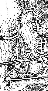
Map of Osgiliath's HarbourThese two sides are joined by bridges that are even more nonsensical than the sides themselves. As you can see, near the shore of the East bank are a series of islands that form a natural port separated from the rest of the river. However, both ends of that port are blocked off by bridges. There are numerous docks and wharfs and no way to access them with vessels larger than overgrown canoes.

Then there are the defenses.

Osgiliath’s primary bastion may be on the banks of the river as well, but it’s also as close to the center of the city as you can get without actually getting in the water. That’s it edging slightly into the Northwest portion of the map.

There’s not a single portion of the city that it actually defends.

In fact, the bridges are protecting it from any water bound attacks coming from the sea. This makes no tactical sense.

Added to that, the outer walls don’t feels natural or real. Their perfectly circular arcs don’t conform to the landscape. Rather, they force the landscape to conform to them.

This is city planning at its most draconic, allowing no room for development.

When you look at the contour lines it is clear that the landscape has either been dug out and evened to fit the city, or that the landscape was unnatural indeed. Further, the city has been forced to conform to the walls. There is no waste space inside the walls, nor are there any structures outside.

Then there are the roads. While there are certainly roads which twist and turn like those of London, all of the major roads have been placed with a straight edge.

Unlike London, whose most important streets are the goat paths that were built along first, someone has bulldozed a straight path through whatever development had existed before to create order. As for those that do twist and wiggle many look less like they are wandering someplace and more like they are being impeded and blocked at every turn by the buildings.

Osgiliath, according to this map, just doesn’t feel natural.

It doesn’t look like something that was founded in a place that made sense and then grew from there, it feels like something that was created whole cloth in defiance of the very reason it was located where it is. It simply does not make sense.

So what’s the takeaway here?

The real world map of London makes a better fantasy setting than the fantasy map of Osgiliath.

Looking at a map of London you get this sense of a living, growing city that has a history and a reason to exist. It excites you about the possibilities of being someplace vibrant and a touch unruly.

By comparison Osgiliath feels sterile, like it always has been there and always will be, and never will it be touched by anything so puerile as history.

When you are working to create maps for your fantasy setting take lessons from real world geography.

Real World Maps Make Sense

Build your fantasy cities like the cities actually live. Found them in a location that makes sense, and then have the cities grow up over time around that city. Grab something like Campaign Cartographer, AutoREALM or a blank map; plug in a geography that makes sense for the campaign, and then grow the city over time.

I guarantee that building fantasy maps the way real world maps formed will result in a more natural and exciting setting.

About the Author

James Hinton is an old school gamer who first fell in love with maps thanks to National Geographic. He now lives in Idaho where he spends his time attempting to force his daughters to give up their laptops for AD&D 1st Ed.

Comments

49 responses

  1. Speaking of Tolkien…. I recently watched Battle of the Five Armies, and one thing I can’t get out of my head (I wondered in the second film, too) is how they handled waste and garbage in Lake City. Did they simply toss everything out the windows or let it fall through holes in the floor?

    Every time I see those scenes, I can’t help thinking the water must be filthy enough to disease everyone in town.

    1. well i imagine it was much like venice – http://www.venipedia.org/wiki/index.php?title=Sewage_disposal:

      “Venice has been, historically, one of Europe’s cleanest cities. 15th-century Venetians dealt with their waste by flinging it out into the streets, as many medieval people did; Venice’s streets were made of water, however, and the tides conveniently swept waste out to sea twice a day.”

      makes sense to me, and much better than just throwing it into the street 🙂

      1. Yeah it makes sense to me too. Why have sewage in the streets when you can throw it into the water.

        Does anyone know if the water around lake town has an out flow to the sea or would sewage build up as Theo suggested?

        1. James Hinton

          The Running River flows out of the lake and eventually ends up in the Sea of Rhun.

          However, this doesn’t necessarily mean sanitary conditions would exist. While Venice does provide a good possibility for explaining Osgiliath, Cleveland’s Cuyahoga River provides a good counterexample. Rather than keeping the city sanitary, the Cuyahoga accumulated so much of the city’s waste it has burned thirteen times.

          Still, the Venice example does add some logic. Thanks for providing it, Nate.

    2. Dang it, now you have me wondering. Hmm…

    3. Andrea Back

      Once again, real world cities may hold the answer.
      http://www.venipedia.org/wiki/index.php?title=Sewage_disposal

      That is why, even today, Venetians cringe when they see foreigners happily bathing their feet in the canals.

    4. Having been to Venice… yeah even now you really do not want to swim in the water. I can only imagine how awful it was 500 years ago.

    5. @Theo They probably would just dump everything in the water. Prior to modern sewage systems and cleanliness concerns rivers that flowed through major cities were cesspools of stink and filth. The river carried most of the garbage away, but living downstream certainly wasn’t pleasant. Harbours, Rivers and lakes near cities were often heavily polluted, and no one with any money would live near them, instead the richer parts of town in cities from prior to the mid-1900s are most often up-stream, up-wind, and up-hill from the industry, ghettos and smell of traditional waterfronts.

      Case in point, the moat for the Tower of London was so crammed with garbage, carcasses and other foul outpourings from the surrounding community that it was blamed for the outbreak of the plague that killed Sir Walter Raleigh’s son in 1592. It was still a rotting cesspool when the Duke of Waterloo had it drained in the 1850s.

      1. “the richer parts of town in cities from prior to the mid-1900s are most often up-stream, up-wind, and up-hill from the industry, ghettos and smell of traditional waterfronts.”

        Erik, that’s a great point to remember when designing our own cities. Cheers.

        Nate

        1. James Hinton

          It certainly is a good point! Thanks for adding that to the conversation. It can be a useful way to add a certain gritty realism to a setting.

  2. Wow, that Osgiliath map doesn’t make a lot of sense indeed!

    Good article, but I have one little remark; not all mediaeval cities grew organically. London might be, but there are just as many examples where the city (or parts of it) were planned out. The best example I can think of is my own home town (Elburg, the Netherlands, which looks like a chessboard). City walls were planned out carefully; they were placed way beyond the current outlines of a city, giving it some room to grow. And sometimes a city grew so much that it filled up every free space within its walls. It looks like this happened to Osgiliath as well. What bothers me the most about that map is it’s circular shape. Most city walls are straight, as far as I know.

    1. James Hinton

      Thanks for pointing that out, Pam. I hadn’t realized that about Elburg. Looking at it on a map however, it is a beautiful sight. I find myself wanting to visit. What a wonderful example of planned architecture.

      In many ways Elburg actually proves the rule. While order has been imposed on nature here and the landscape has been altered specifically to the whim of the builders (the moat is a nice touch) the order remains imposed throughout the growth of the city as the grid remained rigidly maintained. Osgiliath’s roads, however, lack any sense of planned order. Only the walls, and a rigid insistence on not expanding beyond the walls, feel planned.

      Thanks for bringing up this example. You have me wanting to visit Elburg.

  3. Fantastic article, I hope that one day I will be able to use these advices in my world generators (WorldEngine) and history simulators (civs). But I have definitely I very long way in front of me before reaching that point.

    1. James Hinton

      You’ll get there. It’s just a matter of practice.

  4. Great read! I’ve been studying Geography for a while to help me in making a map of my fantasy world that makes sense. its rather boring at points, but in the end it will be well worth it!

  5. Technically, Tolkien never mapped Osgiliath – that’s from an ICE game book, which were, well, ‘loose interpretations’ at best.

    My biggest complaint about fantasy maps is what I call ‘The FR Effect’. Look at the London map above. Buildings touch each other all over the place. Look at any Forgotten Realms map. All the buildings are separate entities, grouped so as to form streets.

    The rare city maps we got before Forgotten Realms had buildings like that. Look at the original City State of the Invincible Overlord map.

    You had this effect before – the ICE maps themselves are notorious for showing cities as big cookie-cutter blocks – but after the publication of the original city maps in the original FR boxed set, it became almost impossible to find a city map in any game book that didn’t follow that stupid precedent.

    1. Hey Wayne,

      I’ve not seen the Forgotten Realms maps so I’ll have to track them down and have a look.

      All the best,

      Nate

    2. James Hinton

      Thanks for that example, Wayne. It helps to illustrate the point nicely.

  6. Steve Dempsey

    Great article, Economics, climate and geography are often an after thought in world building. It’s more what it looks like, and Tolkein was very much about the fairy tale vision. His only bit of industralisation was soundly trounced (The Couring of the Shire) and reverted back to the buccolic idyll. However London may have looked a lot less organic if the Evelyn plan (http://www.jpmaps.co.uk/map/id.36659) had been adopted after the great fire and in Paris Hausmann did very much bulldoze his way through existing buildings. The Enceinte de Thiers was an enormous boundary defence too, being 18th century and built thick to withstand cannon and left a very interesting empty zone when it was finally dismantled.

    1. James Hinton

      Tokyo would be a good example of what you were talking about. Tokyo was rebuilt multiple times throughout its history owing to fires (and bombings in WWII), which granted city officials the opportunity to attempt to impose order. If you look at a modern map of Tokyo you can see this effect in actual play. However, what you will notice is that, in the face of reality, this planning has had to make compromises. While grids have been opposed on the individual neighborhoods, the topography of the region means that on the larger scale the grids look less like a chessboard and more like a scattered stack of squares that frequently come into conflict. Major roads often fail to conform to the grid at all.

      Thanks for the comment!

  7. I’m not the biggest Tolkien expert, but isnt Osgiliath a planned city? This could explain some of its flaws.
    Not actually here to defend Tolkien…

    Anyways, as someone who dabbles in fantasy mapping, i find its REALLY hard to create a believable fantasy city map. Most fantasy city maps just look too big/overpopulated for its technologylevel. They look too square/round/checkerpatern… It’s just really hard to ‘create’ a city from scratch since most cities grow over hundreds of years.

    If anyone in the comments has some good links to tutorials, feel free to share!

    1. James Hinton

      My solution is, unfortunately, a rather time consuming one. I build my maps in a fairly organic fashion, starting with a small farm community, then making natural expansions. This includes periodically “burning down” parts of the city and rebuilding them.

      That might make for a nice article in and of itself some time. I may have to think about this.

  8. What’s the source for that Osgiliath map?

    1. Ah good call – I’ll add this to the article.. The source I was given for the map is as follows: http://www.eredhel.tripod.com/membersonly/id16.html

  9. Jeremiah

    A few thoughts, not so much meant as an argument, but for the sake of worldbuilding discussion and considering the history of the cities/cultures/worlds that you hold around your characters.

    I agree that there are some things in the design of Osgiliath that maybe don’t make sense (not to mention some of Tolkien’s other cities.)

    However, the one factor this particular article doesn’t take into account is that Osgiliath did not grow organically the way that London did. Not all cities do. Osgiliath was constructed shortly after the fall of Numenor, by the survivors of that once-great island nation – the most powerful, advanced, and enlightened human kingdom. They were smart, and they likely planned the city.

    At the time Gondor was founded, it was jointly ruled by Isildur and his brother Anarion. Each of these brothers built a city. Isildur constructed the city which would later be named Minas Tirith, Anarion the city which would later be named Minas Morgul. Osgiliath lay roughly halfway between the two, and was the capital of the kingdom, where the two brother kings met to discuss things and govern. It actually makes perfect sense that the city would develop on both sides of the river and have straight streets. It was designed from the beginning, not grown slowly over centuries. (I do agree that by the events of LotR there probably should have been buildings outside of those walls, though even with that there is a possible excuse that the infrequent Orc attacks kept construction and expansion to a minimum for many centuries. By the time LotR takes place, Osgiliath is mostly an old, abandoned wreckage – you can even tell on that map that the bridges have mostly fallen from abandonment.)

    There were also other ports along the river south of Osgiliath, that served as docks for trade, so the bridges that allowed the kings to travel back and forth were likely far more valuable. And as far as defense, there were other defensive points south of Osgiliath (fortresses that defended the trading ports). The city was not constructed with threats from the river as the primary thought, or even threats from Mordor – though by the time the books take place, the primary threat is indeed an overland threat, not a river invasion. With that in mind, I lean toward the idea that the fortress at the heart of the city is meant less for defense and more as a sort of government house from which the two kings would make their decrees.

    London, or a city that developed in the same way that London did, can be a wonderful setting for a story. But when creating a setting, one must also ponder its history and realize that not all cities grow and develop in the same way.

    1. Hey Jeremiah,

      “Osgiliath lay roughly halfway between the two, and was the capital of the kingdom, where the two brother kings met to discuss things and govern. It actually makes perfect sense that the city would develop on both sides of the river and have straight streets.”

      Thanks for sharing this information. The two brothers meeting from either side provides a logical explanation to how the city developed; as a physical symbol of their balanced unity. Though it would also be interesting to know how the city was settled.

      “But when creating a setting, one must also ponder its history and realize that not all cities grow and develop in the same way.”

      Too true. Too ture 🙂

      Nate

    2. James Hinton

      Thanks for the additional history. This certainly does impact how the map should look, and does add some sense to things.

      In terms of Osgiliath being a planned city I’m going to refer to the replies I gave Steve and Pam above. This particular map leaves me feeling that the walls are the only part of the city that were planned.

      Thanks!

  10. This article is bang on. As an amateur historian, a fan of fantasy and a lover of cartography I’ve often hated the fantasy towns and maps that have been used in games, movies, books, etc. They make no sense at all.

    In making my own campaign worlds, I take it even further than you suggest. Creating a new continent means taking into account how rivers, lakes, mountains, swamps, fields, forests and hills are formed. Then you can figure out where the vegetation would grow. The animals. The inhabitants, the trade, the cities, the roads, the industry and so on. Castles, bridges, roads, ports, walls and more all cry out to be put in logical places. They’re all built on the foundation and if that foundation doesn’t make sense, nothing built on it will. But start with the rocks and elevation and then layer onto it and you get a fascinating world that almost writes its own unique history.

    1. James Hinton

      Fantastic comment Erik. The process you take adds additional time, but it pays huge dividends in its sense of reality. In fact I spoke about that meta-level planning in an article I wrote over here: http://ontologicalgeek.com/an-old-school-gamers-take-on-real-world-maps-and-fantasy-campaigns/

  11. Speak of Tolkien’s maps, I made a research on real places that Tolkien drew his maps upon them, you may not believe that those maps are real. You can see it on my website: http://www.except.ir

    1. That’s interested map research you’ve done there M.R. Kamali. I know many cartographers and worldbuilders like to take inspiration from the real world.

      It’s good to see even the great Tolkien leading the way.

    2. James Hinton

      Fantastic! Thanks for sharing your research!

  12. Very Good Article! Chaosium makes excellent reproductions of real world.maps love their 1890s London map for Gaslight. Now to put an adventure in 1653! ( before the fire!l

  13. John Hooper

    My first question is, where does that map come from? You’re writing as though it is Tolkien’s map, but I think it may come from a non-canon Finnish RPG.

    Second, Osgiliath was a planned city, wasn’t it? It seems reasonable to me that it would be arranged in a rectilinear pattern similar to other planned cities.

    Third, I don’t understand your objection to the bridges. They are clearly all drawbridges, and access to the harbor area is through the rotating or elevating bridge/barrier at its northwest corner. The southeast quarter is accessed by anther drawbridge, that is depicted raised on the map.

    Your points are valid in general. An unplanned, organic city should look more like the map of London, not the map of Osgiliath. However, you’re criticizing the map of Osgiliath as though it were depicting something it is not.

    1. James Hinton

      Hello John.

      You are correct that this was someone else’s map of Tolkein’s city. The article criticizes the map, not Tolkein himself. I’m not aware of any map of Osgiliath that Tolkein himself created.

      Please see my replies to Pam and Steve (above) in regards to the planned nature of Osgiliath.

      As for the bridges, the gaps you are seeing aren’t drawbridge locations, Rather, this map depicts the ruins of Osgiliath, where the bridges have by and large collapsed. Still, drawbridges would help undermine some of my criticism, so world builders should keep them in mind a solutions for their own cities.

  14. Michael Lush

    I was looking at star forts early today, from the look of it Geneva in 1841 is almost as unrealistic as Osgiliath http://en.wikipedia.org/wiki/Star_fort#Construction

    1. James Hinton

      Star forts are a fascinating case of imposing personal will on the surrounding landscape. One thing I will point out about them is that they were considerably smaller than Osgiliath and still ruinous to pay for. Still, the point stands. We can impose on the landscape to some extent. Thanks for pointing this out.

  15. Nathan Irving

    I did a village map recently and posted it online. The only criticism, from two different people, was that it didn’t have enough defenses and wasn’t realistic.

    The irony was that it was heavily based on two real-world villages. Not every village was a fortified stronghold. A village of 800 people, approached by an army of 5,000 or more, does not defend to the last man. They raise a new flag and wave at the nice soldiers passing through. Fantasy RPGs seem to have taught everyone that every village has walls, a castle, a noble, and a town guard that acts like they don’t live there.

    1. James Hinton

      Too true! The majority of towns lacked walls, as they were ruinously expensive to build and maintain. They generally were only built around strategically critical locations.

  16. Except Osgiliath didn’t grow up from cow villlages – it was founded as a capital and is over a thousand years old at the time of the map (ps, you didn’t credit the map but I’m assuming it’s from MERP). Being founded by an advanced civilization colonizing a large depopulated continent there’s a reason for it to look more like Washington DC than London.

    1. James Hinton

      See my replies to Steve and Pam regarding the planned nature of Osgiliath. Thanks for the reply!

  17. I am not sure I understand your point. Compare with other cities like Paris (see for instance those old maps). Concentric building on both shores, many bridges, the Castle of the Louvre is at the center of the city. In fact, Osgiliath looks a lot like that ! 🙂

    1. James Hinton

      Paris grew beyond its original borders, leaving the castle in the center. Osgiliath, however, never did. Still, it’s a good point. Thanks Phersu.

  18. You’re placing too much importance on London as a single data point here. The lack of development on the South Bank of the Thames is because the deep channel of the river favors the north bank, so that’s where the shipping jetties were built. This bias in the river channel is unusual, which is why you see plenty of other medieval trading towns with developments on both sides of the river.

    In the particular case of London, this bias was further enhanced by the fact that the South Bank flooded more frequently and more seriously than the north side of the river.

    Meanwhile, your “no bridge” hypothesis for London’s development is, I’m sorry to say, complete nonsense. You’re right that the first bridge would have blocked traffic passing upriver from London… which is why London exists. The Roman’s built a bridge there, which turned into a de facto location for trade.

    1. James Hinton

      Thanks for the added details for London. I’ll have to re-examine my criticism on that basis.

      1. Another minor historical point: the Tower of London wasn’t built to defend London against attack: it was built “against the restlessness of the huge and brutal populace” – essentially, to prevent revolts in London and put them down and stop them spreading should they arise, as were the other two castles (Montfichet’s and Baynard’s) built on the perimeter of London around the same time. That said, the location makes sense either way: where you’d position a castle to keep people in is much the same as where you’d put it to keep those same people out.

  19. I’ve never seen that map of Osgiliath. I’d be curious where you found it; certainly not in any books I have (and is it JRR or his son?). The maps in the book (keep in mind LOTR Isn’t a trilogy – the first three books are two ‘books’ each but it is meant to be one story) don’t show close-ups of the cities, that much is for sure. That or I am very forgetful. But never mind the latter part; let’s assume it IS what Tolkien himself (and not referring to his son) envisioned.

    You’re criticising the map of a city in Middle-earth. Yes, the idea of ‘Middle earth’ (contrast ‘Middle-earth’ of Tolkien) isn’t Tolkien’s but you’re comparing a fantasy world to a real life world. Therefore you’re comparing a map of a fantasy world to a map of a real life world. Will you next be critical of the magic of the One Ring? What about the magic of Saruman? Hobbits? Elves? List goes on. If not, why criticise the maps? Attempting to compare fantasy with real life in many things (including whether it is logical or illogical) is an immediate failure (wonder why telling someone that they’re deluded and that their belief is completely illogical and not based on reality, won’t do an ounce of good…).

    Elaboration with some points to remember (I’m a long time programmer and designer to a fantasy game that is around 20 years old, if you want to know but really that isn’t relevant)): it can’t be completely realistic. Sure, you CAN make it that, but it will make some things so much harder (and much more boring as well as.. real; decide what you want). The reference to magic is important, actually: magic can solve almost every single problem. Combine it with the fourth dimension (the two go together extremely well) and every seemingly illogical point is now entirely logical (for a fantasy world with magic, which funnily enough Middle-earth has). So unless you’re designing a real life world you’re going about it the wrong way. It is different to try to make a logical map that is consistent and logical within the world in question but what is consistent and logical in one world isn’t necessarily the same as different worlds. Not all worlds are based on the same ideas, though.

    In the end, the question you try to answer can’t be answered one way or another; it is entirely based on what is envisioned by the designers (envision and planning, is rather important, however). As such, there isn’t one right answer (no answer is more right than any other). Also, what is illogical now might have been logical before (or logical in the future) and it goes the other way around. If there wasn’t actual evidence of dinosaurs then many would find it hard to believe that those creatures ever existed, and there would be many claiming it is a made up story. Most people today have no idea just how far technology (thinking of computers) has progressed, even in the past 25 years (major progressions!), because either a) they weren’t alive or b) they weren’t involved with them. Better example: the way the continents are laid out today… very different from what it used to be, it is thought, and I would argue it’ll change over time, further (most likely long after we’re all dead).

    Just some thoughts…

  20. I understand the logic you outline for the placement of river fortifications: if the main threat by water would come from downriver, the fort should be downriver of the town proper, etc.

    But what would you suggest for a coastal city, where the threat by sea could come straight in or from either direction along the shore?

Leave a Reply

Your email address will not be published. Required fields are marked *